 |
| Giant deer dance statue, Obregon Sonora At over 30 meters high it is the tallest sculpture in Latin America The sculptor’s intention was to represent the Danza de Venado (deer dance) a traditional dance of the Yaqui ethnic group native to this area |
On Saturday October 29 we left Totanaka RV park just before 9 a.m. headed to Los Mochis for the night. The drive would be uneventful, even though we went through Vicam which usually has “illegal” tolls manned by locals with ropes who request “donations” usually at least 50 pesos (approx $3.50 Cdn). We were through Vicam fairly early at 10 a.m so perhaps that was the reason - too early on the weekend? Who knows. We were glad not to have to deal with that. Shortly after Vicam the road turned to crap with potholed pavement and many topes (speed bumps). The road went between bad and good stretches with some newly paved stretches mixed with those yet to be fixed. All in all the road was much better than I remembered it was last year. The real test would be the following day in the stretch from Los Mochis to Mazatlan which was undeniably the worst stretch of roads we’d ever experienced - hence one blog post from last year titled “Shake, Rattle and HOLE!”.
The only eventful part of the day was when we missed the turn to get onto the 15D toll road that goes around the city of Obregon. Having missed it, we were routed through the city of Obregon but it wasn’t bad at all. In fact, even though we know the toll road is beautiful around Obregon (from our experience returning home last year) driving through the city is very easy. It has large roads with no obstructions like low hanging trees or wires and good signage to get you through the city. In the end we probably saved at least $30 in tolls by going through the city instead of taking the toll. We’d do it again.
Once through Obregon we returned to the 15D toll road and headed to Navajoa. There is no bypass around Navajoa, but like Obregon it is easy to drive through with wide roads and good signage. And, when exiting there is a large grocery store called Soriana’s that has an RV friendly parking lot. We stopped there to stock up on some more groceries so that once we made it to LDM we would be able to relax and not have to get back on the road to go re-stock our groceries.
We ended our day arriving at the Smart Gas in Los Mochis just after 3 p.m. but there had also been a time change, losing one hour so it felt like 2:15 for us. A nice short driving day all in all. We had stayed in the Smart Gas parking lot last year too. It’s a nice gated lot with an onsite security guard. It’s a large lot where RV’ers typically park far in the back away from the transport trucks and the highway. A small caravan of RV’ers also spent the night there at the same time as us. Most were headed to Mazatlan with a few headed to Lo de Marcos (LDM).
 |
| iOverlander is a great app to find free spots to boon dock Click on any image to make it larger |
 |
| Sunrise in the Smart Gas rear lot, Los Mochis October 29, 2022 |
San Carlos, Sonora to Los Mochis, Sinaloa
End Time - 3:15 p.m. (*we lost one hour due to a time change)
On Sunday October 30 after filling up our tanks we headed for Mazatlan. We were only one night away from our final destination of LDM!! 🎉
We started the day early before 8 a.m. We already knew from last year that we could expect at least six tolls during this stretch. And, that it was the worst stretch of road in the entire journey. All we could hope for was that some work had been done on the heavily pot holed roads. The best way to describe the drive this day was “off and on”. There were definitely some very good stretches where it was evident the road had been completely re-paved mixed in with some old and badly pot holed stretches. All in all, I’d say the roads were somewhat better than they were last year for this same stretch.
Another fun new addition was the state police’s attempts to deter speeding. They do this by putting up 3D painted cardboard cut outs of State police cars! They look pretty good from a distance. Sadly, I didn’t get any pictures of on the way down. I’ll try to snap at least one on the way back. I wonder if they’re effective?
We made it to Mazatlan just shortly after noon and rather than stop (which we likely should have done in hindsight) we decided we had a few more hours of driving left in us. The roads after Mazatlan were really good and we still had a lot of daylight left so we forged on. Once again I turned to the iOverlander app to see what options we had for overnight stays once we passed Mazatlan. I found a post for a Pemex GasMaz station that looked really good. Large cement lot fully fenced with lots of other amenities too. Claimed by the reviewer to be the “best” rest stop in all of Mexico. It was actually very much like a US rest stop too with a lounge area, laundry facilities and showers etc. Our challenge came in getting there!
The map showed we’d stay on the 15D toll road the entire way but would have to go past the station and turn around because it was on the wrong side of the highway with a median dividing the lanes. We didn’t think much of it, surely the turn around would be easy to navigate given how nice the stop was. Duh - we forgot we were in Mexico! BUT that wasn’t the worst part! The worst part was that somewhere along the route our phone GPS popped up a message that I only partially caught. Something about “a faster route is available, click yes to accept”. Well, learning that the “faster route” is often not RV friendly, I ignored the message and we kept on our way. SOMEHOW though, it must have thought we said YES to that “generous” offer and so when we were only supposed to be 5 minutes from our stop it routed us off the toll road and into the small town of Escuinapa de Hidalgo. AND when the GPS told us to turn off the toll road Dan correctly said to me, “NO we stay on the toll road”…then he added “Right?” And silly me, I told him to listen to the damn GPS. DUMB DUMB DUMB!!! ARGH.
 |
| Map showing where we turned off the 15D headed into Escuinapa de Hidalgo |
So, on we went down this very quiet two lane paved road through farmers fields before it dropped us smack dab in the middle of this busy small town! We thought for sure we were going to get pulled over by local cops and taken for a “ride”. We’d heard from fellow RV’ers that this area had “men in black” pulling people over and padding them down apparently looking for people smuggling money into Mexico for the cartels. Frantically, I reset the GPS back to the “Pemex GasMaz” station co-ordinates through iOverlander. Unfortunately it kept routing us right to the centre of this small cramped and very busy town. You’d think for a Sunday it might be quiet, but it was also the final days leading up to Dia de muertos (day of the dead) so it was very very busy. The Google street view image below doesn’t show the scale of how full the streets were. Imagine cars on both sides of each road and people everywhere! Ay Yai Yai!
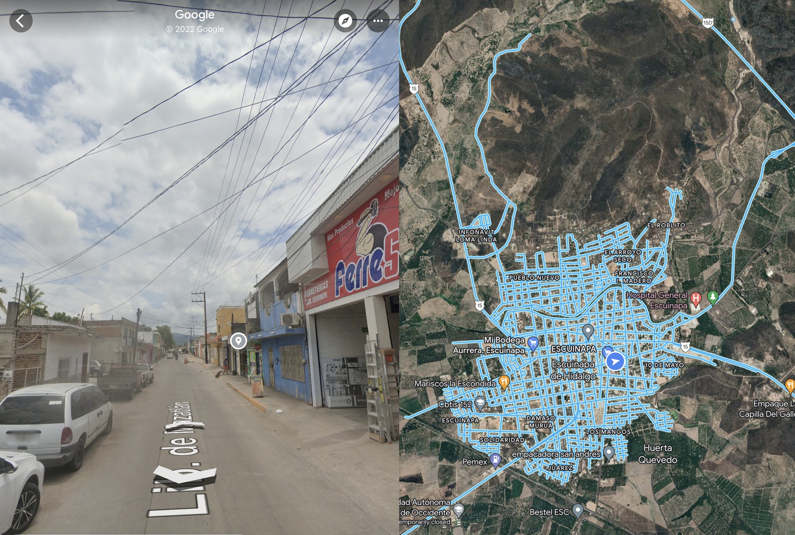 |
| The blue arrow shows how we needed to weave through the centre of this town to get back onto the 15D. Let’s just say it didn’t get us to our final destination any quicker 🤦🏻♀️ |
 |
| Distance between the GasMaz station (upper left) and the small town to turn around in |
 |
| No street view of this small dirt road town, but from the highway turn off I think you can get an idea of what we were driving into. Long days make for poor decisions! |


Los Mochis, Sinaloa to Escuinapa de Hidalgo, Sinaloa
End Time - 3:00 p.m.


No comments:
Post a Comment